Lat/Long Table to Feature Class using Modelbuilder
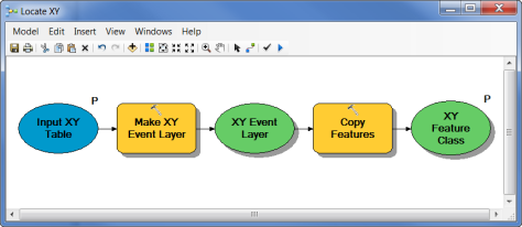
Going from a flat table with latitude and longitude to a point feature class in ArcGIS Desktop using ModelBuilder can, at first, be a somewhat daunting task. My first attempt at this took most of a morning. Accomplishing this requires using the Make XY Event Layer and Copy Features Tool together as shown in the image below.

The reason for needing both of these tools is Make XY Event Layer only creates an event layer, a representation of the locations stored in RAM. The data is not permanent yet. To make the data permanent as a feature class, this is what Copy Features does. Hopefully this makes your life easier than my own, so you do not spend the better part of a morning trying to figure this out.
