Download Raster Tiles from an Image Service in ArcMap

Image services created from mosaic datasets can be set up to enable downloading of individual tiles through client applications including ArcMap, web mapping applications and custom ArcGIS Runtime applications. In ArcMap individual tiles can be downloaded from this image service. This can be used to make available data covering a large spatial extent or data with multiple rasters covering the same area due to multiple resolutions of data or data captured at temporal intervals.
Setup Mosaic Dataset
This workflow facilitates download of mosiac dataset tiles in an area of interest from a mosaic dataset through an image service. As part of the mosaic dataset creation process, overviews and optionally pyramids should already be created along with statistics calculated for the individual raster tiles and the mosaic dataset. Overviews and pyramids are downsampled copies of the raster facilitating display at smaller scales. Statistics define the range of values present, facilitating display and visualization. After this preparation an image service can be created from the mosaic dataset.Ensure Image Service Download Capablity Enabled
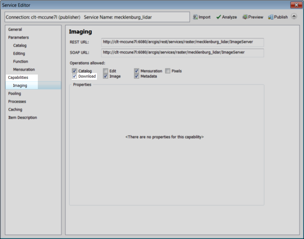
Image services must have the download capablity enabled before end users can download individual raster tiles. By default download capability is not be enabled. To download raster tiles from an image service, the download capability needs to be explicitly enabled. It can be enabled during the initial image service setup or through the image service properties after the image service has already been created.Download capablity can be setup during the initial image service creation in the Service Editor dialog. Under capablities and Image, locate and check the box for Download capability. Enabling download capablity on running image service is possible through the service properties. Service properties are accessible through either ArcCatalog or the ArcGIS Server Manager.
Service properties are accessible in ArcCatalog through a connection to the server using either an account with administrative or publishing privilages. Locate the image service. Right click the image service. Select Service Properties from the context menu. From here the dialog is identical to the Service Editor dialog encountered when publishing. Under capablities and Image, locate and check the box for Download capability.
It is also possible to enable download capablity through the ArcGIS Server Manager. This can be accessed by using a web browser to navigate to http://<servername>:6080/arcgis/manager. After logging in using an account with administrative or publishing prilages, navigate to Services > Manage Services and locate and click on your image service. This will display the service properties. In service properties, locate Capabilities on the left side of the page. Under Operations Allowed, check the box next to Download.

Whether enabled while creating the image service or after the service is created, enabling download allows client applications to download individual mosaic dataset tiles through the image service. These client applications include anything capable of accessing and using ArcGIS Server rest endpoints. This includes ArcMap, a web application or even a custom ArcGIS Runtime application. Most commonly, this will be accessed through ArcMap.
Download Rasters
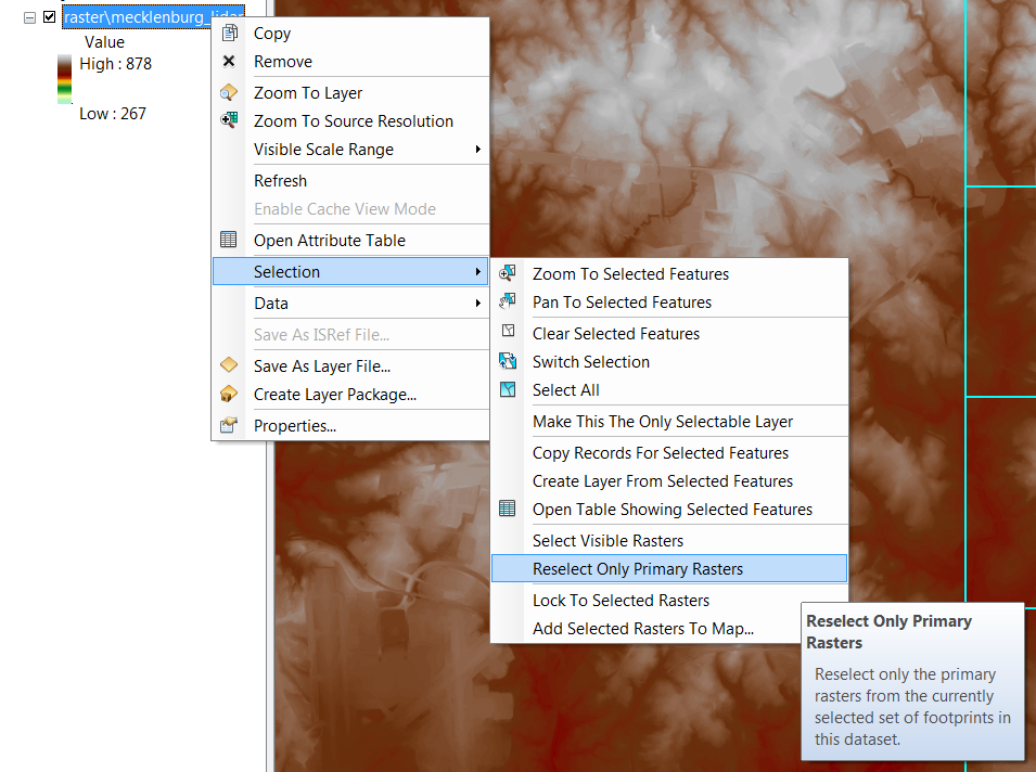
Downloading rasters locally from an image service is possible both interactively or through geoprocessing. If downloading the tiles interactively, first add the image service to ArcMap. Next, identify and select rasters in the area of interest. Then deselect the overview rasters. Finally, download the raster tiles to a local location.It is possible to use any selection method to identify the area of interest. This can include interactive selection, select by location or select by graphics. Interactive selection is the selection tool on the standard toolbar. Select by location is useful if you want to use another feature, such as a country, state or county polygon, to identify the area of interest. Select by graphics requires first drawing a shape, such as a rectangle, to delineate the area of interest and using this to select rasters in the area of interest.

Selected rasters will include all rasters in this area of interest, including all overview rasters. Before extracting, overviews need to be excluded from the selection. Accomplish this by right clicking on the image service layer. From the context menu, go to Selection > Reselect Only Primary Rasters.
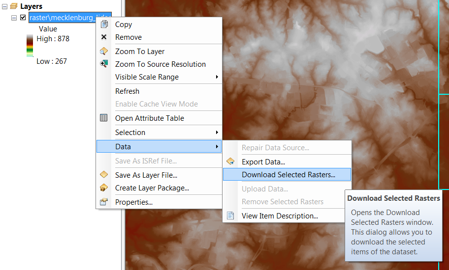
With only the primay rasters selected in the area of interest, the raster tiles can be downloaded by right clicking on the image service layer and then going to Data > Download Selected. A dialog will display enabling you to download the desired rasters.
This same download capability is available using the Download Rasters geoprocessing tool. It is located in Data Management Tools > Raster > Raster Dataset. This tool compresses all the above steps into a single tool. Required parameters include specifying the source Image Service and Output directory for saving the raster tiles locally. It is beneficial to select the tiles before running this tool, since it makes selecting the rasters much easier.