Joel McCune
  • Home
  • About
  • Python
  • Whitewater
  • Geography Matters

ArcGIS

A collection of 28 posts

Python

Conda and ArcGIS Pro 2.7

For those of us who regularly work with Python and ArcGIS, especially for data science, life just got a lot easier with ArcGIS Pro 2.7. Now, arcpy can be installed just like any other Conda package. This means ArcGIS Pro now can coexist on the same machine and play nicely with Conda.

  • Joel McCune
    Joel McCune
3 min read
Python

Create `arcgis` Conda Environment with a Batch File

Although first and foremost a Geographer, after transitioning to the GeoAI Business Development Team at Esri, now I spend most of my time in Jupyter Lab. 
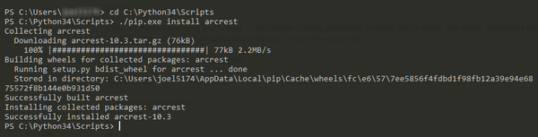
Although not altogther difficult, if following best

  • Joel McCune
    Joel McCune
1 min read
Python

Automatically Convert to Esri Spatially Enabled Dataframe

I frequnetly need a Spatially Enabled Dataframe from a variety of sources, and these sources frequently change. Guessing there is a very good chance I am not the only one doing this - here is my solution to this as a Gist you are more than welcome to use.

  • Joel McCune
    Joel McCune
1 min read
Python

Relative Module Imports in an ArcGIS Python Toolbox

The idea of ArcGIS Python toolboxes really appeals to me. I really like them. As is frequently the case in life, the devil is in the details. Python Toolboxes have plenty of interesting

  • Joel McCune
    Joel McCune
1 min read
iPython

Layer to Spatially Enabled DataFrame

As I continue to dive deeper and deeper into the intersection of Geography and Artifical Intelligence - what we are calling GeoAI, I find myself doing a lot of data work. This means

  • Joel McCune
    Joel McCune
1 min read
Python

Purge Scratch GeoDatabase

In a lot of the scripts I write, especially data preparation pipelines, I use the scratch Geodatabase - a lot. At the end of these pipelines, especially when testing and re-running the processes

  • Joel McCune
    Joel McCune
1 min read
arcpy

Use ArcPy to Match Spatial Reference

Frequently when performing data preparation or analysis in GIS the spatial reference or projections need to be modified to match. Also, much of the time the data needs to be modified to match

  • Joel McCune
    Joel McCune
1 min read
Python API

Loading a Previously Saved SpatialDataFrame from CSV

Increasingly I find myself working with SpatialDataFrames for analysis in Jupyter Notebooks in Python. Much of the time the easiest way to save results for future work is saving to a CSV file.

  • Joel McCune
    Joel McCune
1 min read
Python

Creating a SpatialDataFrame from a Web GIS Item

The relatively recent addition of the SpatialDataFrame object to the ArcGIS Python API was a gigantic leap forward. The SpatialDataFrame marries the common data structure used for data munging and data science, the

  • Joel McCune
    Joel McCune
1 min read
Python

Keeping the ArcGIS Python API with ArcGIS Pro Current

If you are running the ArcGIS Python API in a virgin Conda environment, this very likely does not apply to you. If you are running the ArcGIS Python API in the Python environment

  • Joel McCune
    Joel McCune
1 min read
Pandas

Filter NotNull Geometries in an ArcGIS SpatialDataFrame

When working with Pandas DataFrames it is fairly common to filter out records with null values using the notnull Pandas function. This however, does not work with the geometry column created when loading

  • Joel McCune
    Joel McCune
1 min read
ArcGIS

ArcGIS Python Reproject Geometry Object List

Frequently I have a large list of geometry objects I need to get reprojected for analysis. A while back I discovered the reprojectAs method of the arcpy.Geometry object. While useful, I still

  • Joel McCune
    Joel McCune
2 min read
Python

ArcPy Field Name List

Frequently, especially when using cursors, I need to quickly get a list of field names not including the ObjectID nor Geometry fields. I accomplish this by using a quick shorthand function. fields_list

  • Joel McCune
    Joel McCune
1 min read
Python

ArcGIS to Pandas Data Frame

With the release of ArcGIS 10.4, a few packages included have come to my attention. While numpy has been in there for quite some time, now scipy and pandas are now included.

  • Joel McCune
    Joel McCune
1 min read
Python

Installing Python Packages on an ArcGIS Python Installation

It is little secret I use a ton of Python to get tasks in ArcGIS done. If serious about getting volumes of data processed with ArcGIS, Python is far and above the way

  • Joel McCune
    Joel McCune
3 min read
grocery

Grocery Home Delivery with ArcGIS

Most of the time my work related blog posts are much more on the side of technical and less on the side of marketing. This particular post likely ebbs more toward the latter

  • Joel McCune
    Joel McCune
1 min read
ArcGIS

Cleanse Feature Class Names in Python

Today I ran across a problem with what should be a simple solution, but took me the better part of the morning to figure out...primarily because I was not familiar enough with

  • Joel McCune
    Joel McCune
1 min read
ArcGIS

The Feature Class in ArcGIS

A feature class is a single geometry with an attribute table...period. True, it should also have a spatial reference, and likely needs one to function correctly. Still, in the simplest form, all

  • Joel McCune
    Joel McCune
2 min read
ArcGIS

Create List of Unique Table Values using Data Access Module

A while back I posted a slightly more verbose solution for this. Since then two things have changed. First, I have used Python a LOT more and understand how to use sets, lists

  • Joel McCune
    Joel McCune
1 min read
ArcGIS

Lessons Learned and Ideas for Python Toolbox Coding

Note: A colleague asked for a ready to run PyScripter template implementing these suggestions. This template can now be found on GitHub at: https://github.com/knu2xs/python-toolbox-template. Instructions for using PyScripter to

  • Joel McCune
    Joel McCune
6 min read
ArcGIS

SDE Workspace Creation Toolbox

As an instructor teaching ArcGIS Server classes, I frequently have the need to quickly set up new enterprise geodatabases for teaching demonstrations. To streamline this process, I recently created an ArcGIS Python Toolbox

  • Joel McCune
    Joel McCune
1 min read
ArcGIS

Set Up PyScripter to Create ArcGIS Python Toolboxes

For the last year or so, my Python IDE of choice has been PyScripter. Recently I have started to create ArcGIS Python Toolboxes. PyScripter is still my editor of choice for this task.

  • Joel McCune
    Joel McCune
5 min read
ArcGIS

Create Custom GPX to Features Tool for Garmin Data Collection

26 Jan 2013 Update: The developer who maintains this tool discovered this post last week, got in touch and asked for a sample GPX file. He implemented a fix to recognize the <

  • Joel McCune
    Joel McCune
4 min read
ArcGIS

Download Raster Tiles from an Image Service in ArcMap

Image services created from mosaic datasets can be set up to enable downloading of individual tiles through client applications including ArcMap, web mapping applications and custom ArcGIS Runtime applications. In ArcMap individual tiles

  • Joel McCune
    Joel McCune
4 min read
ArcGIS

Publish a Cached Map to ArcGIS.com Without Burning Credits

Publishing a map to ArcGIS.com, typically it is preferable to cache the map for faster rendering and performance. However, the larger the spatial extent, the more credits will be used to create

  • Joel McCune
    Joel McCune
6 min read
Joel McCune © 2021
Latest Posts Ghost