Joel McCune
  • Home
  • About
  • Python
  • Whitewater
  • Geography Matters

Python API

A collection of 5 posts

Python

Automatically Convert to Esri Spatially Enabled Dataframe

I frequnetly need a Spatially Enabled Dataframe from a variety of sources, and these sources frequently change. Guessing there is a very good chance I am not the only one doing this - here is my solution to this as a Gist you are more than welcome to use.

  • Joel McCune
    Joel McCune
1 min read
Python API

ArcGIS-ML-Docker

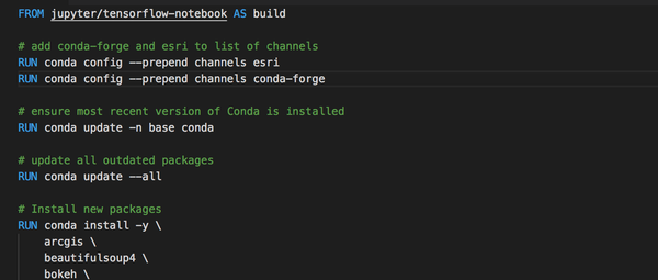
Easily 80 percent of my time at work is now spent in ArcGIS Python API, either the stable branch, or much of the time, the daily build. Frequently I switch between these environments,

  • Joel McCune
    Joel McCune
1 min read
Python API

ArcGIS Python Geometry from Shapely

The ArcGIS Python API Geometry object includes the capability to export the geometry to a Shapely Geometry object, but not the capability to create a new ArcGIS Geometry object from a Shapely object.

  • Joel McCune
    Joel McCune
1 min read
Python API

Loading a Previously Saved SpatialDataFrame from CSV

Increasingly I find myself working with SpatialDataFrames for analysis in Jupyter Notebooks in Python. Much of the time the easiest way to save results for future work is saving to a CSV file.

  • Joel McCune
    Joel McCune
1 min read
Python

Creating a SpatialDataFrame from a Web GIS Item

The relatively recent addition of the SpatialDataFrame object to the ArcGIS Python API was a gigantic leap forward. The SpatialDataFrame marries the common data structure used for data munging and data science, the

  • Joel McCune
    Joel McCune
1 min read
Joel McCune © 2021
Latest Posts Ghost